A Future in Orbit (1): Earth

Space is increasingly present throughout the media, but there is still limited discussion about the major implications of these rapid space technology advancements. To shed some light on what’s going on up there, we are launching a series of posts, A Future in Orbit, to reveal the importance of building infrastructures for space exploration.
Over the next few weeks, we’ll present the main use cases of space, the great technological leap awaiting us, and how to establish humans as a sound space civilization through standardized infrastructure and economic integration. In this piece we put the spotlight on spaceflight close to home — in Earth orbit.
What is LEO?
LEO stands for “low Earth orbit” — the altitude of 100 to about 2000 kilometers above the Earth’s surface where most spacecraft fly. There is also medium (MEO) and high Earth orbit (HEO), but the number of satellites in those orbital regions is quite small comparatively.
LEO is where the International Space Station operates, as well as most imaging satellites. Out of more than 3,300 active satellites presently in orbit, some 3,200 are in LEO.
The unsung epic of LEO data
LEO satellites — especially imaging ones — provide invaluable insights about our planet and human activities. A single satellite camera can have a swath of hundreds of kilometers, meaning that everything on the Earth’s surface within this field will be visible to the satellite and, depending on the camera’s resolution, the image can provide a broad range of insights once processed.
An imaging satellite orbits the planet and snaps such images continuously; if it’s in polar LEO, it will be able to photograph virtually every corner of the planet. One of the simplest and most widely used indicators derived from satellite images is Normalized Difference Vegetation Index (NDVI), which visualizes plant health — be it in forests, agricultural areas, or anywhere else. NDVI is used to monitor the loss or expansion of biomass, crop growth, seasonal variance in vegetation cover or wildfire damage.

Considering that Earth’s 7.8-billion population consumes an increasing amount of food, satellites will be indispensable to implement data-driven precision agriculture generating better yields from existing land and water resources. With more satellite data on soil quality, water availability, weather patterns and crop growth over selected time periods, farmers can become more profitable and efficient in their output, getting closer to resolving a key challenge to human prosperity — food availability.
Of course, weather data is intrinsically tied to adequate agricultural decisions. After all, farmers need to know what rainfall amounts to anticipate, or be warned of impeding storms, and generally stay informed about incoming weather patterns so they can manage their crops effectively. And it’s not only farmers that benefit — it’s the transportation industry too, including airlines — which carried 4.5 billion passengers in 2019 — and maritime transport, which moves around 90% of all traded goods on the planet. Deny them of a weather forecast and they may incur huge losses.
Weather forecasting can be done not just with imagery from weather satellites like NOAA-19, but also with radio occultation (RO) data. RO is increasingly used to improve forecasting precision. The principle is straightforward — radio signals are beamed from a GPS (or other navigation) satellite to a LEO satellite through the Earth’s atmosphere; the changes in the signal are then interpreted to take measurements of the atmosphere’s temperature and composition, adding another data vector to the mix.
Of course, there are many other uses of LEO. Synthetic-aperture radar (SAR) is a type of non-optical imaging with exceptional precision and penetrating capability. SAR satellites have a resolution down to centimeters, detecting even small changes in geological features; they can also penetrate cloud cover and light concealment, revealing otherwise obscured or purposefully hidden objects, such as military equipment under tarps. LEO relay satellites can be used to improve marine traffic and coordination, like Norsat-1. We won’t even mention security applications, which are the origin story of satellite imaging.
But perhaps the most visible use case in the media (and the skies) recently are broadband internet constellations like SpaceX’s Starlink or OneWeb. Why are those important? Well, some 40% of the world population — or almost 4 billion people — still have no internet connection. Broadband constellations will provide internet access to anyone, including areas where building fiber wouldn’t be feasible, which in turns enables even more more satellite data usage in all economic segments.
So where’s the catch?
It’s simple — all that data is generated up there, in orbit. We have to transmit it back to Earth so we can start using it and deliver all those benefits. The infrastructure which handles this is called the ground segment.
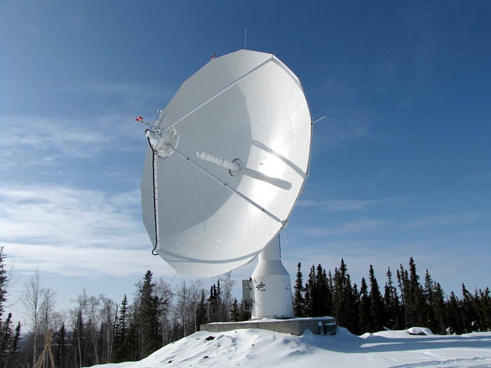
In narrow space tech terms, this means ground stations — antennas which receive the data and then store it locally or forward it to a storage where it’s ready for processing. The more ground stations are available to service a satellite, the more often this satellite can transmit its data back to Earth. When an entire constellation of satellites is adequately serviced by numerous ground stations, then features like rapid revisit — where an area is imaged from space by many satellites — become available more often and generate tremendous insights.
In broader terms, however, the ground segment includes a number of other components, like storage and processing capability. This is a major bottleneck. For example, NASA’s RO datasets have been underutilized because of limited storage and processing capabilities. The solution seems to be migration to a centralized corporate cloud. But do we really want valuable LEO data to be entirely carried and handled by huge cloud providers, making landowners, climate scientists, and a myriad of other actors across the globe dependent on an oligopoly of corporate cloud platforms?
In fact, this is precisely the trend we’re observing. Until recently, most agencies and companies used to build their own stations and storage infrastructure. But much of this in-house capability has aged, and was expensive to set up in the first place. This is why Ground-Segment-as-a-Service (GSaaS) appeared. This is the business of leasing existing stations to space enterprises — in combination with a cloud platform. AWS Ground Station is one major example. Other providers offer similar services, and they are using corporate cloud for their operations.
Even if that was not the case, we have another bottleneck that remains unresolved — namely, the lack of free markets for satellite data, especially images. It’s not just difficult to buy satellite images. It’s ridiculously difficult. Most suppliers of satellite imaging data cater to very large customers, especially government and military users, who are secure clients willing to pay anything for the data. The distribution of satellite data to smaller users is prohibitive because most suppliers are stuck in outdated offering methods, narrow-minded sales patterns, and a centralized control mentality. But they also lack adequate tools to address this lack of marketplaces.
Let’s call it — LEO needs a new type of infrastructure.
It’s obvious that if we want to unlock the full potential of satellite data, there’s a lot of work to do. The means to receive, store, process, and sell satellite data must be changed radically.
We began work on HomePort as a means to supply the demand in a specific niche, which is ground stations. But stations are merely gateways. They are the entry point for a resource — data — which must then be converted into a valuable product and properly distributed.
Ephemeris blockchain protocol will enable this integrated data infrastructure. It will encompass the following:
- HomePort, our decentralized ground station network. It makes it easy for space enterprises to rent ground station capacity. HomePort is a decentralized marketplace for active ground stations where any station operator can offer their antenna to a space company without brokerage. The transaction is secured by a smart contract and oracle engine which largely automate and verify the process in a way that is not possible with legacy methods…unless you want to sign paper contracts.
- Ephemeris storage, which will unlock a decentralized, zero-trust storage infrastructure where satellite data can be securely stored on an existing decentralized cloud — according to the user’s needs, and independently of corporate cloud providers.
- Ephemeris Computation, a distributed computation grid. Anyone with a device capable of computing will be able to contribute their power to process data, giving space enterprises the ability to crunch data without depending on traditional cloud.
Furthermore, Ephemeris will enable:
- A permissions layer;
- Decentralized satellite data marketplaces;
- An environment to build and offer services to the space industry — including dapps for anything from data utilization to launch insurance.
- New types of satellite data cubes.
With an incentive system provided through the Ephemeris utility token, the protocol can become the basis of a new space economy — one where users across the globe can transact securely and fairly; where space services are much more easily available and impact Earth’s economy directly; and where infrastructures carrying critical data cannot be monopolized. Unleashing the potential of Earth orbit operations is immense — and we must unlock it to transform agriculture, transport, science and security. With Ephemeris, wide participation in the new space economy will be made possible for everyone.
Up next: Token utility; A Future in Orbit (2); Partnership Updates.